
| Carrabelle east to St Marks, FL SALTWATER BOAT RAMPS (Carrabelle, Lanark, St Teresa, Alligator Point, Ochlockonee Bay, Levy Bay, Oyster Bay, St Marks NWR, Panacea, St Marks, Apalachee Bay ) |
| . |
View Carrabele to St Marks Saltwater Boat Ramps in a larger map
| Carabelle area Saltwater Boat Ramps |
| (MS) (Allen's) Dockside Marina Boat Ramp 292 Graham Dr Carrabelle, FL 32322 (850) 697-3337 N 29 50.94 W 84 40.01 For more information, click on the following links: Dockside Marina Boat Ramp Last visited/updated: June 2011 |
| Carrabelle City Boat Ramp 4th St/Hwy 98 Carabelle, FL 32 (850) N For more information, click on the following links: Carrabelle City Boat Ramp Last visited/updated: June 2011 |
St Teresa, Alligator Point area Saltwater Boat Ramps |
Panacea area Saltwater Boat Ramps & Launches |
| City Waterfront (Marine St) Boat Ramp South end Marine St Carrabelle, FL 32322 N Newly refurbished double ramp at the south end of Marine St For more information, click on the following links: Last visited: June 2011 |
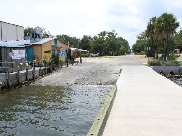
| (The) Moorings Boat Ramp 1000 Ave A North Carrabelle, FL 32322 (850) 697-2800 29.85212 -84.67519 Goggle Maps format N 29 51.127' W 84 40.511' GPS format Fee: $10.00 daily Call for overnight & slip fees, open times For more information, click on the following links: The Moorings (Carrabelle) Boat Ramp The Moorings website Last visited: Aug 2011 |
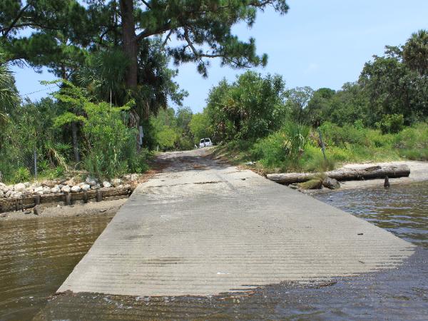
| Timber Island Boat Ramp East end, Timber Island Rd FL 323 N For more information, click on the following links: Timber Island Boat Ramp Last visited: June 2011 |
| Lanark Village Boat Ramp Hwy 98 FL 323 N For more information, click on the following links: Lanark Boat Ramp Last visited: June 2011 |
| St Teresa Boat Ramp Hwy 98 St Teresa, FL 323 N For more information, click on the following links: St Teresa Boat Ramp Last visited: |
| Sun & Sands Boat Ramp Hwy 98 St Teresa, FL 323 N For more information, click on the following links: Sun & Sands Boat Ramp Last visited: |
| Ochlockonee Bay Bridge Boat Ramp Southwest end, Hwy 98/Ochlockonee Bay Bridge , FL 323 N For more information, click on the following links: Ochlockonee Bay Boat Ramp Last visited: |
| Marsh Island Park Boat Ramp East end of Mashes Sand Rd (CR 372) Panacea, FL 323 WCPRD for information, 850-926-7227 29.97253 -84.34567 Google Maps Format N 29 58.352' W 84 20.740' GPS Format Wakullka County operated boat ramp and park. For more information, click on the following links: Marsh Island Park Boat Ramp Wakulla County web site Last visited: Aug 2011 |
| Bottoms Rd Boat Ramp South end, Bottoms Rd Panacea, FL For more information, click on the following links: Bottoms Road Boat Ramp Last visited: |
| Ochlockonee River State Park Boat Ramp Ochlockonee River State Park N For more information, click on the following links: Last visited: |
| Levy Bay Rd Boat Ramp South end, Levy Bay Rd Panacea, FL N For more information, click on the following links: Levy Bay Road Boat Ramp Last visited: |
| Rock Landing Boat Ramp (Port Panacea Boat Ramp) East end, Rock Landing Rd Panacea, FL N For more information, click on the following links: Rock Landing Boat Boat Ramp Last visited: |
| Skipper Bay Rd Boat Ramp Skipper Bay Rd Panacea, FL N For more information, click on the following links: Skipper Bay Rd Boat Ramp Last visited: |
| Wakulla Beach Rd Boat Ramp South end, Wakulla Beach Rd Panacea, FL 32346 N St Marks NWR For more information, click on the following links: Walkulla Beach Road Boat Ramp Last visited: |
| St Marks Lighthouse Boat Ramp South end, Lighthouse Rd (CR 59) St Marks, FL N St Marks NWR For more information, click on the following links: Last visited: |
| Shell Island Fish Camp/Marina Boat Ramp 440 Shell Island Road St Marks, FL 32355 (850) 925-6226 N $ 5.00 to launch, includes parking. Need to watch the tides. For more information, click on the following links: Shell Island Fish Camp Boat Ramp Last visited: |
| Wakulla River/Hwy 98 Bridge Boat Ramp St Marks, FL 32355 (850) 925-6226 N For more information, click on the following links: Walkulla River, Lower Bridge Boat Ramp Last visited: Aug 2011 |
Ochlockonee Bay area Saltwater Boat Ramps |


| Private ? Boat Ramp FL 323 N For more information, click on the following links: Last visited: June 2011 |


| Roho Rd Boat Ramp West end, Roho Rd Panacea, FL N For more information, click on the following links: Roho Road Boat Ramp Last visited: |
| Purify Bay Rd Launch Purify Rd Panacea, FL 32346 N For more information, click on the following links: Purify Bay Launch Last visited: |
| Spring Creek Fish Camp Ben Willis Rd , FL 323 N For more information, click on the following links: Spring Creek Fish Camp Boat Ramp Last visited: August 2011 |
| Live Oak Island Residents Boat Ramp (Private) 4 N For more information, click on the following links: Live Oak Island Residents Boat Ramp (Private) Last visited: |
| Blue Dolphin Rd Boat Ramp S N For more information, click on the following links: Blue Dolphin Rd Boat Ramp Last visited: |
| St Marks Boat Ramp (San Marcos State Park) , FL N For more information, click on the following links: St Marks Boat Ramp Last visited: |


| Alligator Point Boat Ramp H N For more information, click on the following links: Last visited: |

| Bald Point State Park Launch N For more information, click on the following links: Last visited: |


| Marsh Island Park Launch East end of Mashes Sand Rd (CR 372) Panacea, FL 323 WCPRD for information, 850-926-7227 29 Google Maps Format N 29 GPS Format Wakullka County operated park. For more information, click on the following links: Marsh Island Launch Last visited: Aug 2011 |
| Live Oak Island Launch 4 N For more information, click on the following links: Last visited: |
| Skipper Bay Rd Launch East end, Skipper Bay Rd Panacea, FL N For more information, click on the following links: Skipper Bay Rd Launch Last visited: |
| Walker St Launch East end, Walker St Panacea, FL 32346 30.02993 -84.38639 Google Maps Format N 30 1.796' W 84 23.184' GPS Format St Marks NWR For more information, click on the following links: Walker Street Launch Last visited: Aug 2011 |
St Marks area Saltwater Boat Ramps & Launches |


| Bottoms Rd Launch Bottoms Rd Panacea, FL For more information, click on the following links: Bottoms Road Launch Last visited: |

